Ukraine - Bessarabia - and Kiev - Invasion via Front Door
Posted: Sun Apr 06, 2014 8:32 am
Bessarabia's military value is it's strategic location across the Southwestern entry way to the Eastern European Plain.
Both Russia and Ukraine are already inside that door, on the East European Plain, which has been the, tried and true, land invasion route ( and the land trade route ) from the North of Ukraine ( Scandinavia ) and Northeast of Ukraine ( Russia ), to the Southwest land entry way to the Eastern European Plain ( Bessarabia), and to the Black Sea at the port of Odesa.
The East European Plain is relatively flat, overwhelming treeless, and except for rivers, the perfect country for massive tank armies to advance rapidly hundreds of miles in a matter of hours, or a day or two.
The keys to crossing Ukraine with such an army are:
1. Pick a route that avoids crossings rivers entirely, or if they must be crossed, only tiny, "jumpable" rivers and streams. Rivers near their source, where they are just tiny streams ( or diked canals in areas of developed farm land) can be "jumped" with tracked bridging equipment that travels with modern tank armies. Alternately the rapidly moving tank armies may simply capture existing, permanent, small bridges ( over small streams ) intact.
2. There must be a rail line that allows the logistics tail to literally travel immediately behind the tank army. This is also the easiest way to deliver the majority of tanks to where they may be needed in a major battle. Tanks riding on rail cars do not break down on their way to the battle.
3. Bridges over wide, deep, rivers that can not be avoided, must be captured intact by air mobile forces before the arrival of the tank army. Airports near major bridges, or better yet, near both ends of major bridges, can be captured to bring in motorized infantry equipment, anti-tank weapons, heavy weapons, and ammunition for heavy weapons, that give the infantry a fighting chance against enemy armor until the invading tank army arrives.
Linked are railroad maps and watershed maps showing rivers, streams and dividing lines between watersheds.
Google satellite, and Google Earth are very useful to verify just how tiny rivers are at their head waters, and also to verify that the country is wide open, suitable for tank armies, and not closed in by forests.
Place names on the maps are in Romanticized Ukrainian, or Romanticized Russian, however, Google searches will identify the corresponding English name.
Identify for yourself which route would be the fastest, and with the least bridges over significant rivers, between Kursk in Russia, and the Ukrainian & Moldovian regions between the Southern Bug River and the D'niester River, where the Russian Occupation forces in Moldova are already located.
Southern Bug River:
http://upload.wikimedia.org/wikipedia/c ... sBugas.png
D'niester River:
http://upload.wikimedia.org/wikipedia/c ... er_map.png
Watershed Map ( Drill-able Map) :
http://upload.wikimedia.org/wikipedia/c ... %D0%B8.jpg
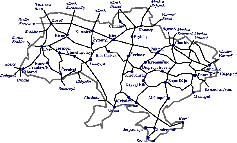
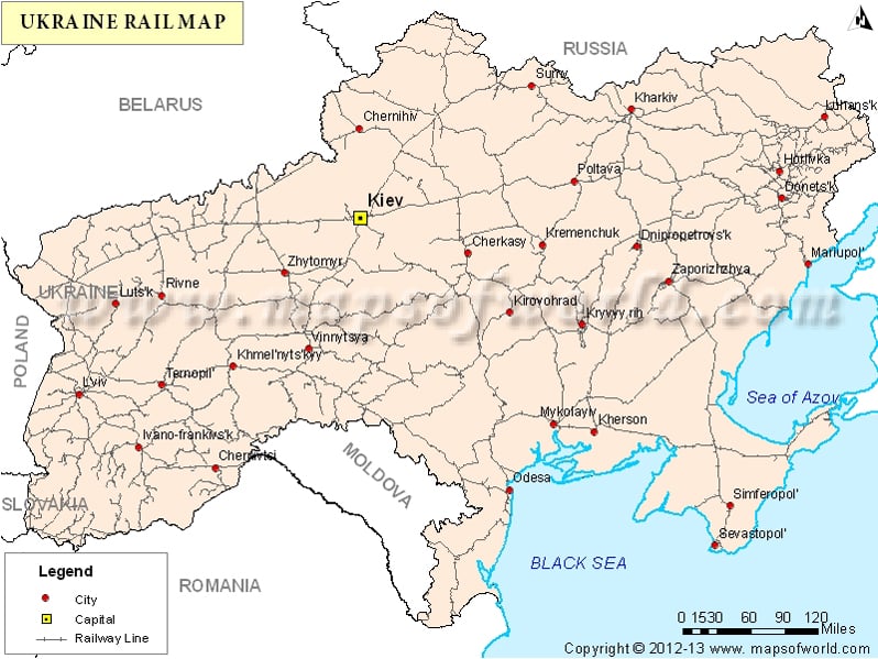
Rail Road Maps:
http://www.rt-operator.ru/files/documen ... kraine.gif
http://upload.wikimedia.org/wikipedia/c ... kraine.png
http://www.mapsofworld.com/ukraine/maps ... il-map.jpg
http://mapofeurope.com/wp-content/uploa ... jpg?616c43
Vinnytsia_International_Airport: Runway 13/31 8,200 Feet (IATA: VIN , ICAO: UKWW)
Near Bridges over "Southern Bug River"
Location on Google Maps: https://www.google.com/maps/place/49%C2 ... :0x0?hl=en
Zhuliany International Airport ( Near West End Kiev Bridges - over D'nieper River )
https://www.google.com/maps/place/Zhuli ... 3693bee0c3
Boryspil International Airport ( Near East End Kiev Bridges - over D'nieper River )
https://www.google.com/maps/place/Kyiv+ ... 5d49d870da
Both Russia and Ukraine are already inside that door, on the East European Plain, which has been the, tried and true, land invasion route ( and the land trade route ) from the North of Ukraine ( Scandinavia ) and Northeast of Ukraine ( Russia ), to the Southwest land entry way to the Eastern European Plain ( Bessarabia), and to the Black Sea at the port of Odesa.
The East European Plain is relatively flat, overwhelming treeless, and except for rivers, the perfect country for massive tank armies to advance rapidly hundreds of miles in a matter of hours, or a day or two.
The keys to crossing Ukraine with such an army are:
1. Pick a route that avoids crossings rivers entirely, or if they must be crossed, only tiny, "jumpable" rivers and streams. Rivers near their source, where they are just tiny streams ( or diked canals in areas of developed farm land) can be "jumped" with tracked bridging equipment that travels with modern tank armies. Alternately the rapidly moving tank armies may simply capture existing, permanent, small bridges ( over small streams ) intact.
2. There must be a rail line that allows the logistics tail to literally travel immediately behind the tank army. This is also the easiest way to deliver the majority of tanks to where they may be needed in a major battle. Tanks riding on rail cars do not break down on their way to the battle.
3. Bridges over wide, deep, rivers that can not be avoided, must be captured intact by air mobile forces before the arrival of the tank army. Airports near major bridges, or better yet, near both ends of major bridges, can be captured to bring in motorized infantry equipment, anti-tank weapons, heavy weapons, and ammunition for heavy weapons, that give the infantry a fighting chance against enemy armor until the invading tank army arrives.
Linked are railroad maps and watershed maps showing rivers, streams and dividing lines between watersheds.
Google satellite, and Google Earth are very useful to verify just how tiny rivers are at their head waters, and also to verify that the country is wide open, suitable for tank armies, and not closed in by forests.
Place names on the maps are in Romanticized Ukrainian, or Romanticized Russian, however, Google searches will identify the corresponding English name.
Identify for yourself which route would be the fastest, and with the least bridges over significant rivers, between Kursk in Russia, and the Ukrainian & Moldovian regions between the Southern Bug River and the D'niester River, where the Russian Occupation forces in Moldova are already located.
Southern Bug River:
http://upload.wikimedia.org/wikipedia/c ... sBugas.png
D'niester River:
http://upload.wikimedia.org/wikipedia/c ... er_map.png
Watershed Map ( Drill-able Map) :
http://upload.wikimedia.org/wikipedia/c ... %D0%B8.jpg
Rail Road Maps:
http://www.rt-operator.ru/files/documen ... kraine.gif
http://upload.wikimedia.org/wikipedia/c ... kraine.png
http://www.mapsofworld.com/ukraine/maps ... il-map.jpg
http://mapofeurope.com/wp-content/uploa ... jpg?616c43
Vinnytsia_International_Airport: Runway 13/31 8,200 Feet (IATA: VIN , ICAO: UKWW)
Near Bridges over "Southern Bug River"
Location on Google Maps: https://www.google.com/maps/place/49%C2 ... :0x0?hl=en
Zhuliany International Airport ( Near West End Kiev Bridges - over D'nieper River )
https://www.google.com/maps/place/Zhuli ... 3693bee0c3
Boryspil International Airport ( Near East End Kiev Bridges - over D'nieper River )
https://www.google.com/maps/place/Kyiv+ ... 5d49d870da